New Congressional Districts on the Drawing Board
The most dramatic shifts occur when a state as a whole has gained or lost population, resulting in a change in the number of its representatives. There can also be changes when some areas of a state gain or lose population relative to others. Because of the “one man, one vote” principle, districts are expected to be approximately equal in population, as well as compact geographically. And that creates both challenges and opportunities for gamesmanship — especially when the boundaries are drawn by one dominant political party. The time-honored term for this is “gerrymandering,” named after Massachusetts Gov. Elbridge Gerry, who in 1813 created a bizarrely-shaped district in order to give his party more representatives in Congress.
One especially blatant modern example is the 2013 Texas districting map, which — among other problems — split the progressive city of Austin among five congressional districts, all of which had the majority of their population in more conservative suburban or rural counties. Given this shameless attempt to shape the political landscape, it was something of a surprise that one Democrat managed to win and keep a seat in Congress. The map was challenged on grounds that it prevented racial and ethnic minorities from receiving proportionate representation despite the census showing growth in their numbers. Despite these challenges, the map was upheld in a 2020 Supreme Court decision in which the conservative majority ruled that local districting is a state matter over which federal courts have no authority.
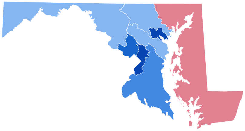
Closer to home, some of Maryland’s current districts are often cited as examples of shameless gerrymandering. Redrawn after the 2010 census by a commission appointed by then-Gov. Martin O’Malley, a Democrat, the boundaries were set up to make seven of the state’s eight districts safe for Democrats. The Third District, which winds erratically from north of Baltimore to the shores of the Chesapeake Bay in Anne Arundel County, and ventures nearly to the border of Washington, DC, in Montgomery County, has been called the most gerrymandered district in the nation by The New Republic. The First District, which includes the entire Eastern Shore plus parts of Baltimore, Harford, and Carroll counties, was set up to give Republicans a shot at one seat in Congress. While Republican Andrew P. Harris has won the district handily in every election since 2010, the district had a distinctly Republican lean well before that redistricting.
Gov. Larry Hogan, a moderate Republican, has tried to establish a better balance by introducing redistricting reform legislation, but the heavily Democratic General Assembly has resisted his effort. Now, Hogan is attempting to bypass the General Assembly by appointing a nonpartisan Maryland Citizens Redistricting Commission, including three members from each of the two major political parties and three independent members. The measure was recommended by a study Hogan authorized in 2015, chaired by two of the members of the current commission. However, any map drawn by the commission will still require approval by the General Assembly, reintroducing the possibility of a political slant.
One problem the commission — or whatever body ends up creating the final map — must face is the necessity of equalizing the districts’ populations. The current districts, whatever else can be said about them, are reasonably well balanced in population, with only about 1.6 percent difference between the largest and smallest. But the Eastern Shore, with just over 500,000 population, needs to combine with some other part of the state to get to the 720,000 figure that represents the average size of the current districts. Moreover, other parts of the state are growing faster than the Shore, in which four counties — Talbot, Dorchester, Somerset, and Kent — actually lost population since the 2010 census. For better or worse, the Shore will need to be coupled with some other part of the state to make up a district.
Another factor, according to a Feb. 18 story in Maryland Matters, is a delay in the release of updated census data until the fall of 2021. That gives the redistricting commission and the General Assembly only a short time to get the new districts defined before Feb. 22, 2022, the filing deadline for candidates. Certainly would-be candidates don’t want to file for the primary only to learn that they don’t live in the district they were planning to run for!
Whether the new district lines will level the playing field — either on the Shore or statewide — remains to be seen. But it would be gratifying to have them drawn in such a way that Maryland is no longer held up, along with Texas, to national ridicule as an example of extreme gerrymandering.
Peter Heck is a Chestertown-based writer and editor, who spent 10 years at the Kent County News and three more with the Chestertown Spy. He is the author of 10 novels and co-author of four plays, a book reviewer for Asimov’s and Kirkus Reviews, and an incorrigible guitarist
Common Sense for the Eastern Shore


